By Dan Smith
The Roanoke Valley has been blessed with some of the most spectacular scenery in the world, and all that’s required to get the best of it are a good pair of hiking boots, a map and being in at least fair physical condition.
If you can see a mountain from any point in Roanoke or a few miles beyond, the chances are good it has a trail to the top, a waterfall somewhere along the way and a challenge for you.
Below are five good hikes—not necessarily the best, depending on what you like—but dependably entertaining hours in nature. This is a lovely place to live, and here’s one way to enjoy it.
Sharp Top, Peaks of Otter
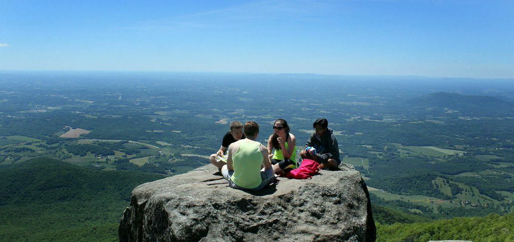
The 3.6-mile, three-hour, sweat-soaked hike up Sharp Top at the Peaks of Otter on the Blue Ridge Parkway is one of the most popular in this region. On a pretty spring or fall weekend day, traffic up the 1,540-foot, rock-strewn climb is belly-to-butt, and the types of hikers are as varied as any segment you’d find on a city street. Hikers and non-hikers, the buff and the hefty, the old and the young, they’re all there, struggling with the rocks and the grade, knowing the payoff will be spectacular.
And it is. This 360-degree view from the top is one of the truly grand views in our mountains, looking east toward Lynchburg, north toward Lexington, south toward Roanoke and west to West Virginia. Look east, then west, and you can see that you’re on the edge of the Blue Ridge Mountains, which sink away as you move toward Lynchburg and get higher toward West Virginia. The ridge lines are clear, clean and striking.

The hike is much more difficult than a 1.8-mile stretch would suggest because it is nearly straight up and even though much of it consists of man-made rock steps, there are stretches where negotiating the sharp rocks is difficult.
The flora and fauna can be as spectacular as the topside view and it’s much more varied, especially in the spring when flowers of all description peek through and provide a touch of grace.
The parking lot is easy to find: across the Parkway from the Peaks visitors center. You begin at the edge of the lot, and if you’re not up for the hike but want the view, you can pay a bus to take you up and/or bring you down.
Stiles Falls at Camp Alta Mons
This is an easy hike, about 3.5 miles round trip through rolling country with three creek crossings and a lovely 75-foot-high waterfall at the end. It can be walked any time of the year, and when the falls are frozen, it is spectacular.

You simply take the only left turn available in the middle of Shawsville and drive about two miles to the camp. It is just a few miles the other side of Salem on U.S. 460 and can be a busy place on pretty days because of its convenience and its ease.
Vegetation is lush through the length of the hike, and there are plenty of uphill stretches to make the exercises worthwhile.
Bottom Creek Gorge
This Montgomery County Nature Conservancy trail has a total of about five miles of various trails, each marked by a color. There is little difference in the difficulty of the trails, though the whole excursion becomes a challenge if you decide to go to the foot of the 200-foot high waterfall at the overlook.

That’s a climb and a workout, but photographing the falls from the bottom is something that not many of the legion of visitors does. The hike is a pretty one—regardless of the trail selected—but the payoff of looking at a distant falls (The Kettles, a series of stair-step falls) is not quite as spectacular as one might imagine.
The hike is filled with hardwoods, hemlocks, wildflowers and an upland meadow. It is not a difficult hike, but it is lovely.
Crabtree Falls

Let’s start with the reality that more than 25 people have died in falls here. It is a steep, sometimes treacherous climb up the side of Virginia’s highest waterfall (actually a series of waterfalls), which is more than 1,200 feet. This is not a long hike at 3.4 miles, but because it is so steep, it feels much longer, and you’ll get a good workout.
The Rockbridge County trail ends at an overlook of the Tye River Valley and the irony of this gorgeous uphill climb is that the view from the top doesn’t include the five major cascades of the waterfall.
Like so many of the region’s hikes with waterfalls as the goal, this is popular and if you’re looking for solitude, you will want to go somewhere else. It is a busy trail, at least partly because of its proximity to the Blue Ridge Parkway, even on cold, overcast days.
It is a little tricky to find if you haven’t been there, but Google it for directions, or simply set your GPS, and take off. There is a $3 parking fee here, and figuring out how to pay at the kiosk is the first challenge of the day.
McAfee’s Knob
You can see this one from Downtown Roanoke. It is the pointed mountain that leans a bit to the right, looking like a cresting wave. And it is one of the most popular hikes in the region, combining a spectacular view with your choice of medium or difficult terrain to climb.
At the parking lot atop Catawba Mountain, you can either take the Appalachian Trail (difficult) or the service road (more moderate). Both intersect with the AT for the final third of the hike, which is about 4.4 miles going up and 1,700 feet of elevation to the Knob. Takes about four hours if you’re in condition.


I’ve never been especially taken with the beauty of most of the hike, since you’re basically in the deep woods with few breaks for views, but the breakout at the top is simply spectacular and features one of the most photographed spots in the entire region. Here’s a tip, though: don’t stop at the Knob. Go an extra 75 to 100 yards around the crest and absorb the view of Roanoke that few know exists. It will give you a different view of the Star City than most of you know.
If you’ve done these hikes and want something different, let me suggest you Google these: North Mountain, Mill Mountain, Read Mountain, The Cascades, Carvin’s Cove/Hay Rock, Apple Orchard Falls, Dragon’s Tooth, Devil’s Marbleyard, Roaring Run, Chestnut Ridge, Explore Park, Poor Mountain Natural Area Preserve, and any of the 20-plus miles of the Roanoke Greenway.
Dan Smith is a member of the Virginia Communications Hall of Fame, and an award-winning journalist, author and photographer who lives in Roanoke.
